Real estate appraisal report of Japan, 〒759-6531 Yamaguchi-ken, Shimonoseki-shi, Yoshimihonmachi, 1 Chome−2−22 山口銀行吉見(支)

37,500 yen
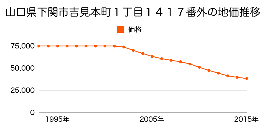
As the result of the real estate appraisal carried out on Jan 01, 2016, the land value for real estate of Japan, 〒759-6531 Yamaguchi-ken, Shimonoseki-shi, Yoshimihonmachi, 1 Chome−2−22 山口銀行吉見(支) was determined for 37,500 yen / m².
Real estate appraisal report (partly written in Japanese)
| Researched at | 01 Jan, 2016 |
|---|---|
| Lot number(Chiban) | 山口県下関市吉見本町1丁目1417番外 |
| Address | 吉見本町1−2−22 Japan, 〒759-6531 Yamaguchi-ken, Shimonoseki-shi, Yoshimihonmachi, 1 Chome−2−22 山口銀行吉見(支) |
| Price | 37,500yen/㎡ |
| Access | Yoshimi , 110 M |
| Acreage | 135㎡ |
| Aspect ratio | 台形(1.5:1.0) |
| Structure | 建物などの敷地、LS(軽量鉄骨造)2F |
| Present | store |
| Water, sewer and gas services | Water, sewer and gas |
| The vicinity | 低層店舗、一般住宅の混在する駅前の商業地域 |
| Main road | south west 12.0m national road |
| The other roads | |
| Allocation of use zoning | neighborhood commercial districts, quasi-fire prevention districts |
| Building‐to‐land ratio, Floor area ratio | 80(%),200(%) |
| Development area | urbanization area |
| Natural environment |
Environment (Written in Japanese)
| 地形・地質 | 扇状地性低地谷の出口など、河川流域の扇状の平地のことである。土地開発は非常に容易であり、造成地の地盤は一般的利用に耐えるものである。 地形性質上洪水や土石流の危険がある地域であり、上流のダム決壊や歴史的豪雨等、数十年から数百年に一度レベルの災害が発生した際には被害地域となる恐れがある。 「国土交通省 地震に対する地盤の安全性 地形分類の評点」:3点(5点満点中) |
|---|---|
| 土地利用・植生 | 水田,宅地 |
| 黄砂エアロゾル | PM10及びPM2.5の飛散が国内においては比較的多いため、対策が必要。精密機器の製造などでは品質に問題を及ぼす可能性もある。 |
| 緯度・軽度 | 東経 34度0692893 北緯 130度9035841 |
Map
Yoshimishimo, Shimonoseki, Yamaguchi Prefecture 759-6523, Japan2 Chome-9-21 Yoshimishinmachi, Shimonoseki-shi, Yamaguchi-ken 759-6532, JapanYoshimishimo, Shimonoseki, Yamaguchi Prefecture 759-6523, JapanYoshimishimo, Shimonoseki, Yamaguchi Prefecture 759-6523, Japan