Real estate appraisal report of Baba-11-1 Miyamachō Tsurugaoka, Nantan-shi, Kyōto-fu 601-0762, Japan

10,200 yen
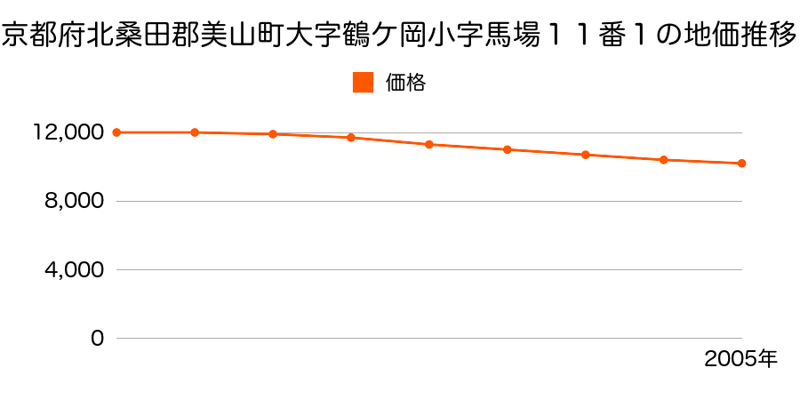
As the result of the real estate appraisal carried out on Jul 01, 2005, the land value for real estate of Baba-11-1 Miyamachō Tsurugaoka, Nantan-shi, Kyōto-fu 601-0762, Japan was determined for 10,200 yen / m².
Real estate appraisal report (partly written in Japanese)
| Researched at | 01 Jul, 2005 |
|---|---|
| Lot number(Chiban) | 京都府北桑田郡美山町大字鶴ケ岡小字馬場11番1 |
| Address | Baba-11-1 Miyamachō Tsurugaoka, Nantan-shi, Kyōto-fu 601-0762, Japan |
| Price | 10,200yen/㎡ |
| Access | Miyama Chouei Basu Tsuru ヶ Oka , 250 M |
| Acreage | 217㎡ |
| Aspect ratio | (1.0:1.0) |
| Structure | 建物などの敷地、W(木造)2F |
| Present | residence |
| Water, sewer and gas services | Water, sewer and gas |
| The vicinity | |
| Main road | east 5.0m city road |
| The other roads | |
| Allocation of use zoning | other areas |
| Building‐to‐land ratio, Floor area ratio | -(%),-(%) |
| Development area | out of city-planning zone |
| Natural environment |
Environment (Written in Japanese)
| 地形・地質 | チャート扇状地性低地谷の出口など、河川流域の扇状の平地のことである。土地開発は非常に容易であり、造成地の地盤は一般的利用に耐えるものである。 地形性質上洪水や土石流の危険がある地域であり、上流のダム決壊や歴史的豪雨等、数十年から数百年に一度レベルの災害が発生した際には被害地域となる恐れがある。 「国土交通省 地震に対する地盤の安全性 地形分類の評点」:3点(5点満点中) 堆積岩堆積岩で出来た土地。地盤の形成された時期によっては液状化などのリスクが有る。 |
|---|---|
| 土地利用・植生 | 水田 |
| 黄砂エアロゾル | PM10及びPM2.5の飛散それぞれ認められるため、対応が必要。 |
| 緯度・軽度 | 東経 35度3201894 北緯 135度5579502 |