Real estate appraisal report of Azumachogodo, Midori, Gunma Prefecture 376-0304, Japan

5,540 yen
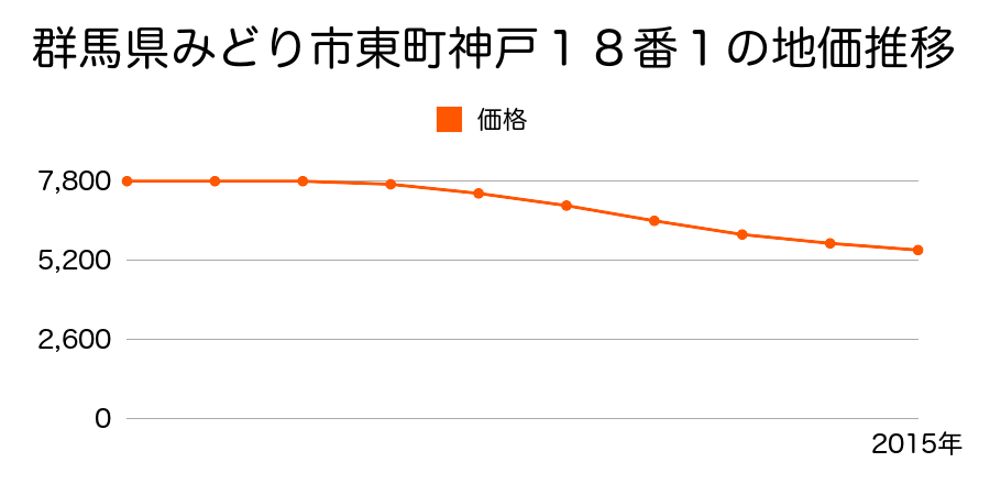
As the result of the real estate appraisal carried out on Jul 01, 2015, the land value for real estate of Azumachogodo, Midori, Gunma Prefecture 376-0304, Japan was determined for 5,540 yen / m².
Real estate appraisal report (partly written in Japanese)
| Researched at | 01 Jul, 2015 |
|---|---|
| Lot number(Chiban) | 群馬県みどり市東町神戸18番1外 |
| Address | Azumachogodo, Midori, Gunma Prefecture 376-0304, Japan |
| Price | 5,540yen/㎡ |
| Access | Koube , 700 M |
| Acreage | 460㎡ |
| Aspect ratio | (1.0:1.5) |
| Structure | 建物などの敷地、W(木造)1F |
| Present | residence |
| Water, sewer and gas services | Water, sewer and gas |
| The vicinity | 一般住宅が建ち並ぶ住宅地域 |
| Main road | west 4.0m city road |
| The other roads | |
| Allocation of use zoning | other areas |
| Building‐to‐land ratio, Floor area ratio | -(%),-(%) |
| Development area | out of city-planning zone |
| Natural environment |
Environment (Written in Japanese)
| 地形・地質 | 未固結堆積物火山砕屑物火山砕屑岩で出来た土地。地盤の形成された時期によっては土砂災害・液状化などのリスクが有る。地形性質上過去に火山災害のあったエリアであるため、現在もそのリスクが無いかの確認が必要。 扇状地性低地谷の出口など、河川流域の扇状の平地のことである。土地開発は非常に容易であり、造成地の地盤は一般的利用に耐えるものである。 地形性質上洪水や土石流の危険がある地域であり、上流のダム決壊や歴史的豪雨等、数十年から数百年に一度レベルの災害が発生した際には被害地域となる恐れがある。 「国土交通省 地震に対する地盤の安全性 地形分類の評点」:3点(5点満点中) |
|---|---|
| 土地利用・植生 | 畑 |
| 黄砂エアロゾル | PM10の飛散は国内においては比較的少ない。PM2.5の飛散については特に少ないというわけでは無いため対策が必要。 |
| 緯度・軽度 | 東経 36度5398411 北緯 139度3498854 |
Map
Godo Station, Azumachogodo, Midori, Gunma Prefecture 376-0304, Japan