Real estate appraisal report of Japan, 〒791-3201 Ehime-ken, Iyo-shi, Nakayamachō Saredani, 丙1069−2

5,000 yen
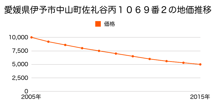
As the result of the real estate appraisal carried out on Jul 01, 2015, the land value for real estate of Japan, 〒791-3201 Ehime-ken, Iyo-shi, Nakayamachō Saredani, 丙1069−2 was determined for 5,000 yen / m².
Real estate appraisal report (partly written in Japanese)
| Researched at | 01 Jul, 2015 |
|---|---|
| Lot number(Chiban) | 愛媛県伊予市中山町佐礼谷丙1069番2 |
| Address | Japan, 〒791-3201 Ehime-ken, Iyo-shi, Nakayamachō Saredani, 丙1069−2 |
| Price | 5,000yen/㎡ |
| Access | Nagasawa Basutei , 2 , 300 M |
| Acreage | 403㎡ |
| Aspect ratio | 台形(1.5:1.0) |
| Structure | 建物などの敷地、W(木造)2F |
| Present | residence |
| Water, sewer and gas services | Water, sewer and gas |
| The vicinity | 農家住宅が建ち並ぶ県道沿いの住宅地域 |
| Main road | north 6.0m prefectural road府 prefectural road |
| The other roads | |
| Allocation of use zoning | other areas |
| Building‐to‐land ratio, Floor area ratio | -(%),-(%) |
| Development area | out of city-planning zone |
| Natural environment |
Environment (Written in Japanese)
| 地形・地質 | 扇状地性低地谷の出口など、河川流域の扇状の平地のことである。土地開発は非常に容易であり、造成地の地盤は一般的利用に耐えるものである。 地形性質上洪水や土石流の危険がある地域であり、上流のダム決壊や歴史的豪雨等、数十年から数百年に一度レベルの災害が発生した際には被害地域となる恐れがある。 「国土交通省 地震に対する地盤の安全性 地形分類の評点」:3点(5点満点中) |
|---|---|
| 土地利用・植生 | 水田,植林地 |
| 黄砂エアロゾル | PM10及びPM2.5の飛散それぞれ認められるため、対応が必要。 |
| 緯度・軽度 | 東経 33度680936 北緯 132度7136062 |