Real estate appraisal report of Tokiwachō-2720 Matsuyamamachi Muramatsu, Kitakata-shi, Fukushima-ken 966-0902, Japan

14,400 yen
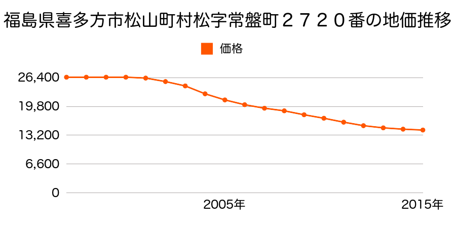
As the result of the real estate appraisal carried out on Jul 01, 2015, the land value for real estate of Tokiwachō-2720 Matsuyamamachi Muramatsu, Kitakata-shi, Fukushima-ken 966-0902, Japan was determined for 14,400 yen / m².
Real estate appraisal report (partly written in Japanese)
| Researched at | 01 Jul, 2015 |
|---|---|
| Lot number(Chiban) | 福島県喜多方市松山町村松字常盤町2720番 |
| Address | Tokiwachō-2720 Matsuyamamachi Muramatsu, Kitakata-shi, Fukushima-ken 966-0902, Japan |
| Price | 14,400yen/㎡ |
| Access | Kitakata , 3 , 400 M |
| Acreage | 454㎡ |
| Aspect ratio | (1.0:3.5) |
| Structure | 建物などの敷地、W(木造)1F |
| Present | residence |
| Water, sewer and gas services | Water, sewer and gas |
| The vicinity | 中規模一般住宅の中に小売店舗等が混在する郊外の住宅地域 |
| Main road | east 8.0m prefectural road府 prefectural road |
| The other roads | |
| Allocation of use zoning | category 1 residential districts |
| Building‐to‐land ratio, Floor area ratio | 60(%),200(%) |
| Development area | city‐planning area |
| Natural environment |
Environment (Written in Japanese)
| 地形・地質 | 扇状地性低地谷の出口など、河川流域の扇状の平地のことである。土地開発は非常に容易であり、造成地の地盤は一般的利用に耐えるものである。 地形性質上洪水や土石流の危険がある地域であり、上流のダム決壊や歴史的豪雨等、数十年から数百年に一度レベルの災害が発生した際には被害地域となる恐れがある。 「国土交通省 地震に対する地盤の安全性 地形分類の評点」:3点(5点満点中) |
|---|---|
| 土地利用・植生 | 宅地 |
| 黄砂エアロゾル | PM10の飛散は国内においては比較的少ない。PM2.5の飛散については特に少ないというわけでは無いため対策が必要。 |
| 緯度・軽度 | 東経 37度6744132 北緯 139度871261 |