Real estate appraisal report of Japan, 〒697-1321 Shimane-ken, Hamada-shi, Sufuchō, イ422
26,300 yen
As the result of the real estate appraisal carried out on Jul 01, 2015, the land value for real estate of Japan, 〒697-1321 Shimane-ken, Hamada-shi, Sufuchō, イ422 was determined for 26,300 yen / m².
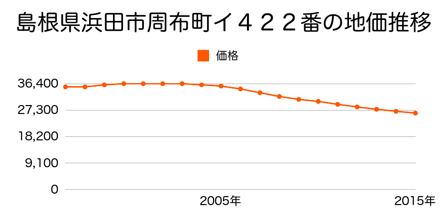
Real estate appraisal report (partly written in Japanese)
| Researched at | 01 Jul, 2015 |
|---|---|
| Lot number(Chiban) | 島根県浜田市周布町イ422番 |
| Address | Japan, 〒697-1321 Shimane-ken, Hamada-shi, Sufuchō, イ422 |
| Price | 26,300yen/㎡ |
| Access | Sufu , 560 M |
| Acreage | 426㎡ |
| Aspect ratio | (1.0:1.5) |
| Structure | 建物などの敷地、W(木造)2F |
| Present | residence |
| Water, sewer and gas services | Water, sewer and gas |
| The vicinity | 一般住宅が建ち並び店舗等も介在する住宅地域 |
| Main road | north west 6.3m city road |
| The other roads | 北東側道 |
| Allocation of use zoning | category 1 residential districts |
| Building‐to‐land ratio, Floor area ratio | 60(%),200(%) |
| Development area | city‐planning area |
| Natural environment |
Environment (Written in Japanese)
| 地形・地質 | 三角州性低地河川の土砂が河口付近に堆積して形成された平野部分であり、長期スパンで見れば洪水の被害に合うリスクの高い地域である。 また、地震に対する地盤の強度も十分ではない。 農業用地として優れているが居住には耐えない。 このような土地を開発してリスクを十分に説明せずに居住用に販売する会社が存在することは嘆かわしいことである。 「国土交通省 地震に対する地盤の安全性 地形分類の評点」:2点(5点満点中) |
|---|---|
| 土地利用・植生 | 水田 |
| 災害リスク:水害 | 洪水氾濫区域(昭和58年(1983)7月 山陰豪雨被害) 過去の周辺地域の水害の確認が必要。 |
| 黄砂エアロゾル | PM10及びPM2.5の飛散が国内においては比較的多いため、対策が必要。精密機器の製造などでは品質に問題を及ぼす可能性もある。 |
| 緯度・軽度 | 東経 34度861511 北緯 132度0214164 |