Real estate appraisal report of Shirahama, Nishimuro District, Wakayama Prefecture, Japan

80,000 yen
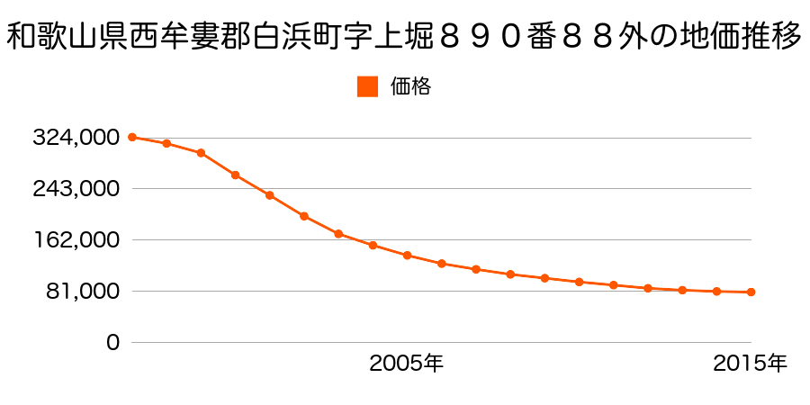
As the result of the real estate appraisal carried out on Jul 01, 2015, the land value for real estate of Shirahama, Nishimuro District, Wakayama Prefecture, Japan was determined for 80,000 yen / m².
Real estate appraisal report (partly written in Japanese)
| Researched at | 01 Jul, 2015 |
|---|---|
| Lot number(Chiban) | 和歌山県西牟婁郡白浜町字上堀890番88外 |
| Address | Shirahama, Nishimuro District, Wakayama Prefecture, Japan |
| Price | 80,000yen/㎡ |
| Access | Shirahama , 4 , 900 M |
| Acreage | 152㎡ |
| Aspect ratio | (1.0:1.5) |
| Structure | 建物などの敷地、RC(鉄筋コンクリート造)3F |
| Present | store, office |
| Water, sewer and gas services | Water, sewer and gas |
| The vicinity | 中低層の店舗等が建ち並ぶ町の中心的商業地域 |
| Main road | south east 12.0m prefectural road府 prefectural road |
| The other roads | |
| Allocation of use zoning | commercial districts |
| Building‐to‐land ratio, Floor area ratio | 80(%),400(%) |
| Development area | city‐planning area |
| Natural environment |
Environment (Written in Japanese)
| 地形・地質 | 砂礫台地砂礫・岩質の土質でできた起伏の少ない地形のことである。土地開発は容易であり、造成地の地質は比較的強固である。 「国土交通省 地震に対する地盤の安全性 地形分類の評点」:3点(5点満点中) 三角州性低地河川の土砂が河口付近に堆積して形成された平野部分であり、長期スパンで見れば洪水の被害に合うリスクの高い地域である。 また、地震に対する地盤の強度も十分ではない。 農業用地として優れているが居住には耐えない。 このような土地を開発してリスクを十分に説明せずに居住用に販売する会社が存在することは嘆かわしいことである。 「国土交通省 地震に対する地盤の安全性 地形分類の評点」:2点(5点満点中) 半固結・固結堆積物不均質かつ未固結な土塊類(あるいは岩塊類)から構成されルーズな土地、斜面はしばしば土砂災害の原因となる。 |
|---|---|
| 土地利用・植生 | 宅地 |
| 黄砂エアロゾル | PM10の飛散は国内においては比較的少ない。PM2.5の飛散については特に少ないというわけでは無いため対策が必要。 |
| 緯度・軽度 | 東経 33度6781645 北緯 135度3481343 |
Map
Shirahama, Nishimuro District, Wakayama Prefecture, JapanShirahama, Nishimuro District, Wakayama Prefecture, JapanShirahama, Nishimuro District, Wakayama Prefecture, JapanShirahama, Nishimuro District, Wakayama Prefecture, Japan