Real estate appraisal report of Japan, 〒739-0033 Hiroshima-ken, Higashihiroshima-shi, Saijōchō Umaki, 565−1 東広島市板城地域センター

55,800 yen
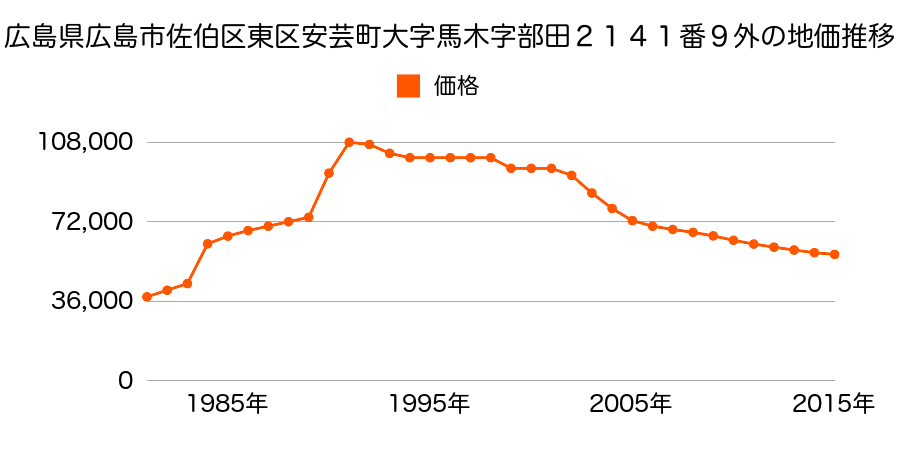
As the result of the real estate appraisal carried out on Jan 01, 2017, the land value for real estate of Japan, 〒739-0033 Hiroshima-ken, Higashihiroshima-shi, Saijōchō Umaki, 565−1 東広島市板城地域センター was determined for 55,800 yen / m².
Real estate appraisal report (partly written in Japanese)
| Researched at | 01 Jan, 2017 |
|---|---|
| Lot number(Chiban) | 広島県広島市佐伯区東区馬木3丁目501番95 |
| Address | 馬木3−11−12 Japan, 〒739-0033 Hiroshima-ken, Higashihiroshima-shi, Saijōchō Umaki, 565−1 東広島市板城地域センター |
| Price | 55,800yen/㎡ |
| Access | Hiroshima , 7 , 700 M |
| Acreage | 221㎡ |
| Aspect ratio | (1.0:2.0) |
| Structure | 建物などの敷地、LS(軽量鉄骨造)2F |
| Present | residence |
| Water, sewer and gas services | Water, sewer and gas |
| The vicinity | 中規模一般住宅が建ち並ぶ高台の閑静な住宅地域 |
| Main road | south east 4.8m city road |
| The other roads | |
| Allocation of use zoning | category 1 low rise-rise exclusive residential districts |
| Building‐to‐land ratio, Floor area ratio | 50(%),100(%) |
| Development area | urbanization area |
| Natural environment |
Environment (Written in Japanese)
| 地形・地質 | 扇状地性低地谷の出口など、河川流域の扇状の平地のことである。土地開発は非常に容易であり、造成地の地盤は一般的利用に耐えるものである。 地形性質上洪水や土石流の危険がある地域であり、上流のダム決壊や歴史的豪雨等、数十年から数百年に一度レベルの災害が発生した際には被害地域となる恐れがある。 「国土交通省 地震に対する地盤の安全性 地形分類の評点」:3点(5点満点中) |
|---|---|
| 土地利用・植生 | 水田 |
| 黄砂エアロゾル | PM10及びPM2.5の飛散それぞれ認められるため、対応が必要。 |
| 緯度・軽度 | 東経 34度3707932 北緯 132度7327697 |
Map
Saijocho Goso, Higashihiroshima, Hiroshima Prefecture 739-0035, JapanSaijocho Goso, Higashihiroshima, Hiroshima Prefecture 739-0035, Japan