Real estate appraisal report of Kamiyamaguchi, Hayama, Miura District, Kanagawa Prefecture 240-0115, Japan

64,500 yen
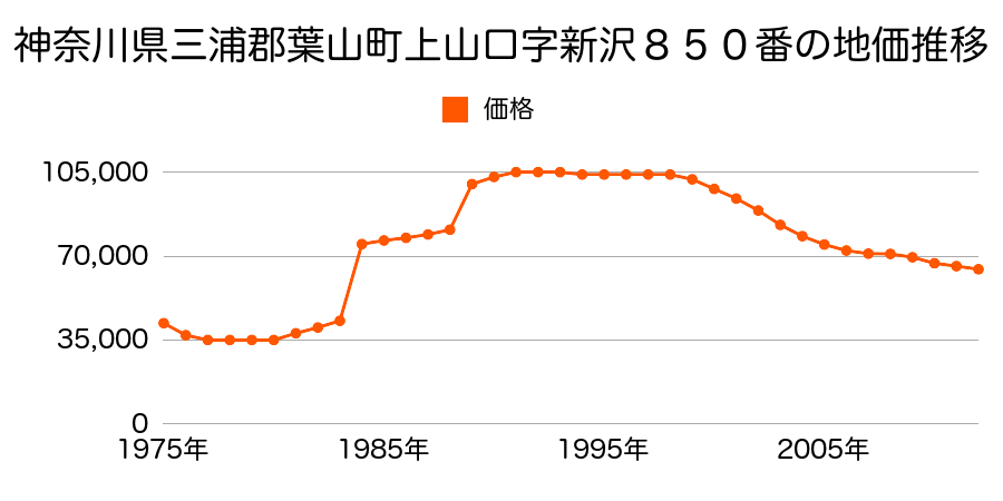
As the result of the real estate appraisal carried out on Jan 01, 2012, the land value for real estate of Kamiyamaguchi, Hayama, Miura District, Kanagawa Prefecture 240-0115, Japan was determined for 64,500 yen / m².
Real estate appraisal report (partly written in Japanese)
| Researched at | 01 Jan, 2012 |
|---|---|
| Lot number(Chiban) | 神奈川県三浦郡葉山町上山口字間門1661番2外 |
| Address | Kamiyamaguchi, Hayama, Miura District, Kanagawa Prefecture 240-0115, Japan |
| Price | 64,500yen/㎡ |
| Access | Zushi , 6 , 000 M |
| Acreage | 259㎡ |
| Aspect ratio | 不整形(1.5:1.0) |
| Structure | 建物などの敷地、LS(軽量鉄骨造)2F |
| Present | residence |
| Water, sewer and gas services | Water, sewer and gas |
| The vicinity | 一般住宅、農家住宅等が見られる住宅地域 |
| Main road | east 7.0m town road |
| The other roads | |
| Allocation of use zoning | other areas |
| Building‐to‐land ratio, Floor area ratio | 50(%),100(%) |
| Development area | controlled urbanization area |
| Natural environment |
Environment (Written in Japanese)
| 地形・地質 | 扇状地性低地谷の出口など、河川流域の扇状の平地のことである。土地開発は非常に容易であり、造成地の地盤は一般的利用に耐えるものである。 地形性質上洪水や土石流の危険がある地域であり、上流のダム決壊や歴史的豪雨等、数十年から数百年に一度レベルの災害が発生した際には被害地域となる恐れがある。 「国土交通省 地震に対する地盤の安全性 地形分類の評点」:3点(5点満点中) 半固結・固結堆積物不均質かつ未固結な土塊類(あるいは岩塊類)から構成されルーズな土地、斜面はしばしば土砂災害の原因となる。 |
|---|---|
| 土地利用・植生 | 宅地 |
| 黄砂エアロゾル | PM10の飛散は国内においては比較的少ない。PM2.5の飛散については特に少ないというわけでは無いため対策が必要。 |
| 緯度・軽度 | 東経 35度2670919 北緯 139度611975 |
Map
Kamiyamaguchi, Hayama, Miura District, Kanagawa Prefecture 240-0115, JapanKikoba, Hayama, Miura District, Kanagawa Prefecture 240-0114, JapanKamiyamaguchi, Hayama, Miura District, Kanagawa Prefecture 240-0115, JapanKikoba, Hayama, Miura District, Kanagawa Prefecture 240-0114, Japan