Real estate appraisal report of Kuninaka, Yazu, Yazu District, Tottori Prefecture 680-0457, Japan

15,700 yen
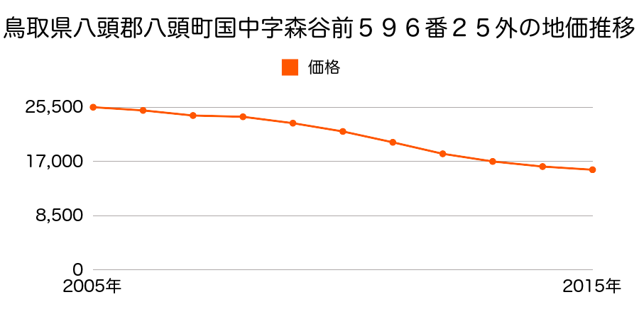
As the result of the real estate appraisal carried out on Jul 01, 2015, the land value for real estate of Kuninaka, Yazu, Yazu District, Tottori Prefecture 680-0457, Japan was determined for 15,700 yen / m².
Real estate appraisal report (partly written in Japanese)
| Researched at | 01 Jul, 2015 |
|---|---|
| Lot number(Chiban) | 鳥取県八頭郡八頭町国中字森谷前596番25外 |
| Address | Kuninaka, Yazu, Yazu District, Tottori Prefecture 680-0457, Japan |
| Price | 15,700yen/㎡ |
| Access | Kawaharaeki , 200 M |
| Acreage | 783㎡ |
| Aspect ratio | (1.0:1.5) |
| Structure | 建物などの敷地、W(木造)2F |
| Present | residence |
| Water, sewer and gas services | Water, sewer and gas |
| The vicinity | 一般住宅の中に店舗等が見られる県道沿いの住宅地域 |
| Main road | south 7.5m prefectural road府 prefectural road |
| The other roads | |
| Allocation of use zoning | other areas |
| Building‐to‐land ratio, Floor area ratio | 70(%),400(%) |
| Development area | city‐planning area |
| Natural environment |
Environment (Written in Japanese)
| 地形・地質 | 半固結・固結堆積物不均質かつ未固結な土塊類(あるいは岩塊類)から構成されルーズな土地、斜面はしばしば土砂災害の原因となる。 扇状地性低地谷の出口など、河川流域の扇状の平地のことである。土地開発は非常に容易であり、造成地の地盤は一般的利用に耐えるものである。 地形性質上洪水や土石流の危険がある地域であり、上流のダム決壊や歴史的豪雨等、数十年から数百年に一度レベルの災害が発生した際には被害地域となる恐れがある。 「国土交通省 地震に対する地盤の安全性 地形分類の評点」:3点(5点満点中) |
|---|---|
| 土地利用・植生 | 水田 |
| 黄砂エアロゾル | PM10及びPM2.5の飛散が国内においては比較的多いため、対策が必要。精密機器の製造などでは品質に問題を及ぼす可能性もある。 |
| 緯度・軽度 | 東経 35度3982383 北緯 134度2216485 |
Map
Kuninaka, Yazu, Yazu District, Tottori Prefecture 680-0457, Japan