Real estate appraisal report of Japan, 〒855-0871 Nagasaki-ken, Shimabara-shi, Minamikueyamamachi, 丁2420−71

23,400 yen
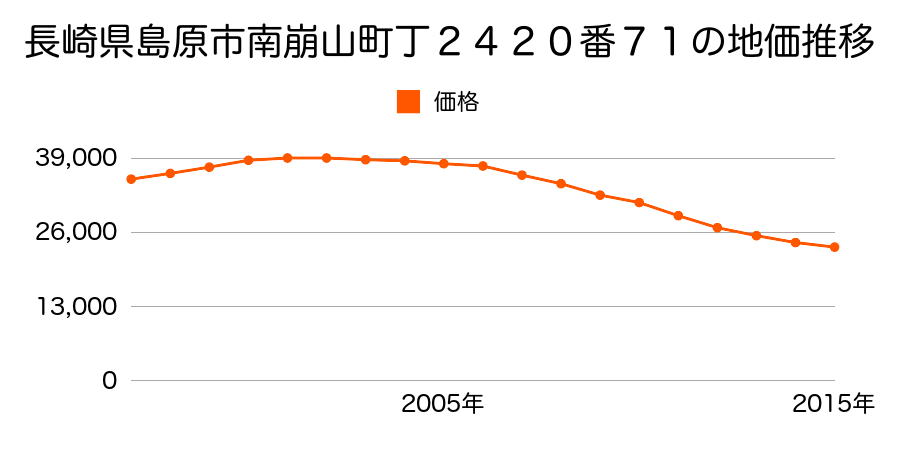
As the result of the real estate appraisal carried out on Jul 01, 2015, the land value for real estate of Japan, 〒855-0871 Nagasaki-ken, Shimabara-shi, Minamikueyamamachi, 丁2420−71 was determined for 23,400 yen / m².
Real estate appraisal report (partly written in Japanese)
| Researched at | 01 Jul, 2015 |
|---|---|
| Lot number(Chiban) | 長崎県島原市南崩山町丁2420番71 |
| Address | Japan, 〒855-0871 Nagasaki-ken, Shimabara-shi, Minamikueyamamachi, 丁2420−71 |
| Price | 23,400yen/㎡ |
| Access | Basu Danchi Mae , 100 M |
| Acreage | 231㎡ |
| Aspect ratio | (1.0:1.0) |
| Structure | 建物などの敷地、W(木造)2F |
| Present | residence |
| Water, sewer and gas services | Water, sewer and gas |
| The vicinity | 中規模一般住宅が建ち並ぶ区画整然とした住宅地域 |
| Main road | south 6.5m city road |
| The other roads | |
| Allocation of use zoning | category 1 medium-to-high-rise exclusive residential districts |
| Building‐to‐land ratio, Floor area ratio | 60(%),200(%) |
| Development area | city‐planning area |
| Natural environment |
Environment (Written in Japanese)
| 地形・地質 | 扇状地性低地谷の出口など、河川流域の扇状の平地のことである。土地開発は非常に容易であり、造成地の地盤は一般的利用に耐えるものである。 地形性質上洪水や土石流の危険がある地域であり、上流のダム決壊や歴史的豪雨等、数十年から数百年に一度レベルの災害が発生した際には被害地域となる恐れがある。 「国土交通省 地震に対する地盤の安全性 地形分類の評点」:3点(5点満点中) |
|---|---|
| 土地利用・植生 | ヤブツバキクラス域代償植生 |
| 黄砂エアロゾル | PM10及びPM2.5の飛散が国内においては比較的多いため、対策が必要。精密機器の製造などでは品質に問題を及ぼす可能性もある。 |
| 緯度・軽度 | 東経 32度7558253 北緯 130度3657736 |
Map
Japan, 〒855-0862 Nagasaki-ken, Shimabara-shi, Shinminato, 2 Chome−丙2077−2