Real estate appraisal report of 433-21 Takanoyamanishi, Tsuyama-shi, Okayama-ken 708-1124, Japan

30,300 yen
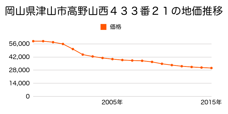
As the result of the real estate appraisal carried out on Jul 01, 2015, the land value for real estate of 433-21 Takanoyamanishi, Tsuyama-shi, Okayama-ken 708-1124, Japan was determined for 30,300 yen / m².
Real estate appraisal report (partly written in Japanese)
| Researched at | 01 Jul, 2015 |
|---|---|
| Lot number(Chiban) | 岡山県津山市高野山西433番21 |
| Address | 433-21 Takanoyamanishi, Tsuyama-shi, Okayama-ken 708-1124, Japan |
| Price | 30,300yen/㎡ |
| Access | Takanoeki , 2 , 600 M |
| Acreage | 202㎡ |
| Aspect ratio | (1.0:1.0) |
| Structure | 建物などの敷地、LS(軽量鉄骨造)2F |
| Present | residence |
| Water, sewer and gas services | Water, sewer and gas |
| The vicinity | 中規模一般住宅の中に空地等が見られる区画整然とした住宅地域 |
| Main road | north east 5.0m city road |
| The other roads | |
| Allocation of use zoning | category 1 medium-to-high-rise exclusive residential districts |
| Building‐to‐land ratio, Floor area ratio | 60(%),200(%) |
| Development area | city‐planning area |
| Natural environment |
Environment (Written in Japanese)
| 地形・地質 | 扇状地性低地谷の出口など、河川流域の扇状の平地のことである。土地開発は非常に容易であり、造成地の地盤は一般的利用に耐えるものである。 地形性質上洪水や土石流の危険がある地域であり、上流のダム決壊や歴史的豪雨等、数十年から数百年に一度レベルの災害が発生した際には被害地域となる恐れがある。 「国土交通省 地震に対する地盤の安全性 地形分類の評点」:3点(5点満点中) |
|---|---|
| 土地利用・植生 | 水田 |
| 黄砂エアロゾル | PM10及びPM2.5の飛散それぞれ認められるため、対応が必要。 |
| 緯度・軽度 | 東経 35度0751938 北緯 134度0458667 |
Map
Takanoyamanishi, Tsuyama, Okayama Prefecture 708-1124, JapanOshiire, Tsuyama, Okayama Prefecture 708-1126, JapanKawanabe, Tsuyama, Okayama Prefecture 708-0842, JapanKawanabe, Tsuyama, Okayama Prefecture 708-0842, Japan