Real estate appraisal report of Tomabechi, Nanbu, Sannohe District, Aomori Prefecture 039-0802, Japan

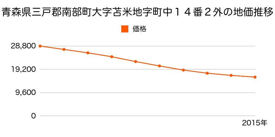
16,000 yen
As the result of the real estate appraisal carried out on Jul 01, 2015, the land value for real estate of Tomabechi, Nanbu, Sannohe District, Aomori Prefecture 039-0802, Japan was determined for 16,000 yen / m².

Real estate appraisal report (partly written in Japanese)
| Researched at | 01 Jul, 2015 |
|---|---|
| Lot number(Chiban) | 青森県三戸郡南部町大字苫米地字町中14番2外 |
| Address | Tomabechi, Nanbu, Sannohe District, Aomori Prefecture 039-0802, Japan |
| Price | 16,000yen/㎡ |
| Access | Tomabechi , 600 M |
| Acreage | 446㎡ |
| Aspect ratio | (1.0:3.5) |
| Structure | 建物などの敷地、W(木造)2F |
| Present | store, residence |
| Water, sewer and gas services | Water, sewer and gas |
| The vicinity | 中小規模の小売店舗等が建ち並ぶ国道沿いの商業地域 |
| Main road | north 10.5m national road |
| The other roads | |
| Allocation of use zoning | other areas |
| Building‐to‐land ratio, Floor area ratio | -(%),-(%) |
| Development area | out of city-planning zone |
| Natural environment |
Environment (Written in Japanese)
| 地形・地質 | 扇状地性低地谷の出口など、河川流域の扇状の平地のことである。土地開発は非常に容易であり、造成地の地盤は一般的利用に耐えるものである。 地形性質上洪水や土石流の危険がある地域であり、上流のダム決壊や歴史的豪雨等、数十年から数百年に一度レベルの災害が発生した際には被害地域となる恐れがある。 「国土交通省 地震に対する地盤の安全性 地形分類の評点」:3点(5点満点中) |
|---|---|
| 土地利用・植生 | 宅地 |
| 黄砂エアロゾル | PM10の飛散は国内においては比較的少ない。PM2.5の飛散については特に少ないというわけでは無いため対策が必要。 |
| 緯度・軽度 | 東経 40度46723739999999 北緯 141度3811245 |
Map
Tomabechi, Nanbu, Sannohe District, Aomori Prefecture 039-0802, JapanAkane-5-39 Fukuda, Nanbu-chō, Sannohe-gun, Aomori-ken 039-0815, JapanAkane-5-39 Fukuda, Nanbu-chō, Sannohe-gun, Aomori-ken 039-0815, Japan
Related information
Tomabechi Station(12,000円 / m²)Kitatakaiwa Station(13,100円 / m²)Kenyoshi Station(14,000円 / m²)Market price in Aomoriken (Descending)
| Higashikougyoumae Station | 68,000 yen / m² |
| Hon Hachinohe Station | 47,850 yen / m² |
| Tsutsui Station | 43,500 yen / m² |
| Aomori Station | 42,700 yen / m² |
| Hirosaki Station | 41,850 yen / m² |
| Higashiaomori Station | 41,300 yen / m² |
| Yadamae Station | 40,100 yen / m² |
| Shinaomori Station | 39,100 yen / m² |
| Mutsuminato Station | 35,750 yen / m² |
| Hirokoushita Station | 35,400 yen / m² |
Market price in Aomoriken (Ascending)
| Nakata Station | 8,850 yen / m² |
| Mokuzou Station | 8,850 yen / m² |
| Kawabe Station | 9,300 yen / m² |
| Fujisaki Station | 9,300 yen / m² |
| Hayashizaki Station | 11,950 yen / m² |
| Ishikawapuurumae Station | 12,100 yen / m² |
| Tateda Station | 12,400 yen / m² |
| Hiraga Station | 12,400 yen / m² |
| Hakunoukoukoumae Station | 12,700 yen / m² |
| Inaka Kan Station | 12,950 yen / m² |
Change of market price in Aomoriken (Descending)
| Shinaomori Station | +23.15% |
| Shimoda Station | +11.76% |
| Hakugin Station | +5.83% |
| Tsutsui Station | +3.2% |
| Yadamae Station | +2.56% |
| Higashiaomori Station | +0.73% |
| Higashikougyoumae Station | 0.0% |
| Akagawa Station | 0.0% |
| Shimokita Station | 0.0% |
| Sogawa Station | 0.0% |
Change of market price in Aomoriken (Ascending)
| Aomori Station | -27.13% |
| Niizato Station | -25.32% |
| Naijoushi Station | -25.1% |
| Sen Nen Station | -24.63% |
| Hirokoushita Station | -17.96% |
| Chuuouhirosaki Station | -16.9% |
| Hirosakihigashikoumae Station | -16.9% |
| Mutsuminato Station | -16.86% |
| Kawabe Station | -12.26% |
| Fujisaki Station | -12.26% |
Market price in Japan (Descending)
| Yuurakuchou Station | 12,200,000 yen / m² |
| Toukyou Station | 12,000,000 yen / m² |
| Kyoubashi Station | 10,365,000 yen / m² |
| Nihonbashi Station | 6,990,000 yen / m² |
| Hacchoubori Station | 6,600,000 yen / m² |
| Sakuradamon Station | 3,155,000 yen / m² |
| Kouji Machi Station | 2,810,000 yen / m² |
| Hanzoumon Station | 2,745,000 yen / m² |
| Takebashi Station | 2,700,000 yen / m² |
| Kudanshita Station | 2,700,000 yen / m² |
Market price in Japan (Ascending)
| Akabira Station | 3,900 yen / m² |
| Kitayoshihara Station | 6,050 yen / m² |
| Hagino Station | 6,700 yen / m² |
| Shintotsukawa Station | 8,050 yen / m² |
| Takigawa Station | 8,100 yen / m² |
| Nakata Station | 8,850 yen / m² |
| Mokuzou Station | 8,850 yen / m² |
| Kawabe Station | 9,300 yen / m² |
| Fujisaki Station | 9,300 yen / m² |
| Motowanishi Station | 10,800 yen / m² |
Change of market price in Japan (Descending)
| Ooizumi Station | +142.74% |
| Hacchoubori Station | +124.87% |
| Jinbou Machi Station | +118.85% |
| Hobara Station | +116.55% |
| Kawasaki Station | +91.72% |
| Akihabara Station | +88.46% |
| Kudanshita Station | +87.5% |
| Takashima Machi Station | +86.73% |
| Bakuro Machi Station | +82.88% |
| Shinokachimachi Station | +71.61% |
Change of market price in Japan (Ascending)
| Higashihonganjimae Station | -73.47% |
| Nagoya Station | -65.43% |
| 西11丁目 Station | -65.01% |
| 西15丁目 Station | -61.59% |
| Chiyokenchouguchi Station | -60.43% |
| Susuki No Station | -59.77% |
| Okayama Station | -57.54% |
| Atagobashi Station | -54.91% |
| 西18丁目 Station | -53.33% |
| Kohashi Station | -52.11% |
