Real estate appraisal report of Japan, 〒731-4213 Hiroshima-ken, Aki-gun, Kumano-chō, Hagiwara, 2 Chome−16−23 クレール山ノ代A

53,500 yen
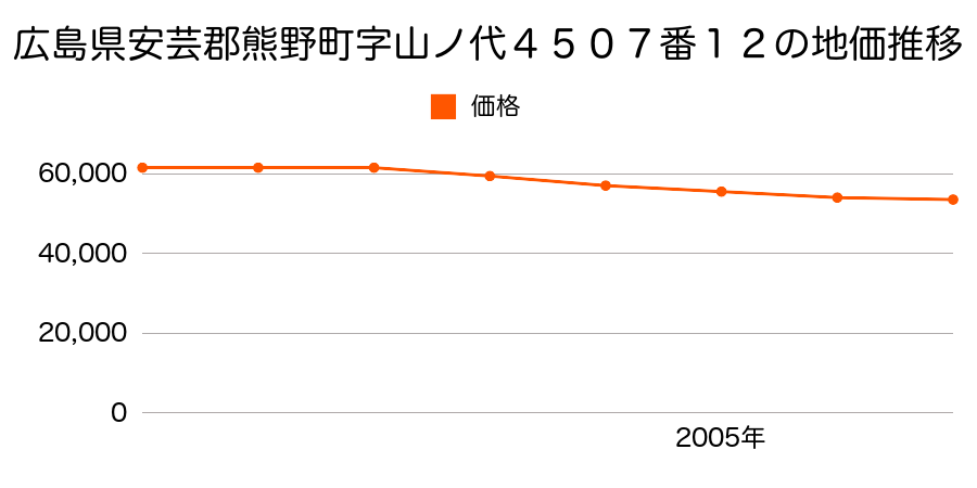
As the result of the real estate appraisal carried out on Jan 01, 2007, the land value for real estate of Japan, 〒731-4213 Hiroshima-ken, Aki-gun, Kumano-chō, Hagiwara, 2 Chome−16−23 クレール山ノ代A was determined for 53,500 yen / m².
Real estate appraisal report (partly written in Japanese)
| Researched at | 01 Jan, 2007 |
|---|---|
| Lot number(Chiban) | 広島県安芸郡熊野町字山ノ代4507番12 |
| Address | Japan, 〒731-4213 Hiroshima-ken, Aki-gun, Kumano-chō, Hagiwara, 2 Chome−16−23 クレール山ノ代A |
| Price | 53,500yen/㎡ |
| Access | Yano , 9 , 300 M |
| Acreage | 195㎡ |
| Aspect ratio | 台形(1.2:1.0) |
| Structure | 建物などの敷地、W(木造)2F |
| Present | residence |
| Water, sewer and gas services | Water, sewer and gas |
| The vicinity | 一般住宅、アパート等が混在する住宅地域 |
| Main road | south east 4.3m road |
| The other roads | |
| Allocation of use zoning | category 1 medium-to-high-rise exclusive residential districts |
| Building‐to‐land ratio, Floor area ratio | 60(%),200(%) |
| Development area | urbanization area |
| Natural environment |
Environment (Written in Japanese)
| 地形・地質 | 扇状地性低地谷の出口など、河川流域の扇状の平地のことである。土地開発は非常に容易であり、造成地の地盤は一般的利用に耐えるものである。 地形性質上洪水や土石流の危険がある地域であり、上流のダム決壊や歴史的豪雨等、数十年から数百年に一度レベルの災害が発生した際には被害地域となる恐れがある。 「国土交通省 地震に対する地盤の安全性 地形分類の評点」:3点(5点満点中) |
|---|---|
| 土地利用・植生 | 水田 |
| 黄砂エアロゾル | PM10及びPM2.5の飛散それぞれ認められるため、対応が必要。 |
| 緯度・軽度 | 東経 34度3361793 北緯 132度5921 |
Map
2 Chome-11-4 Hagiwara, Kumano-chō, Aki-gun, Hiroshima-ken 731-4213, Japan9 Chome-6-32 Jōnohori, Kumano-chō, Aki-gun, Hiroshima-ken 731-4215, Japan5 Chome-9-19 Dekiniwa, Kumano-chō, Aki-gun, Hiroshima-ken 731-4221, Japan5 Chome-4-10 Kawasumi, Kumano-chō, Aki-gun, Hiroshima-ken 731-4223, Japan