Real estate appraisal report of Japan, 〒675-1114 Hyōgo-ken, Kako-gun, Inami-chō, Kuniyasu, 1294−5 加古川市東消防署稲美分署

57,000 yen
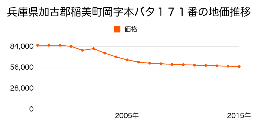
As the result of the real estate appraisal carried out on Jul 01, 2015, the land value for real estate of Japan, 〒675-1114 Hyōgo-ken, Kako-gun, Inami-chō, Kuniyasu, 1294−5 加古川市東消防署稲美分署 was determined for 57,000 yen / m².
Real estate appraisal report (partly written in Japanese)
| Researched at | 01 Jul, 2015 |
|---|---|
| Lot number(Chiban) | 兵庫県加古郡稲美町国安字東310番10 |
| Address | Japan, 〒675-1114 Hyōgo-ken, Kako-gun, Inami-chō, Kuniyasu, 1294−5 加古川市東消防署稲美分署 |
| Price | 57,000yen/㎡ |
| Access | JR Doyama , 3 , 300 M |
| Acreage | 127㎡ |
| Aspect ratio | (1.0:1.0) |
| Structure | 建物などの敷地、W(木造)2F |
| Present | residence |
| Water, sewer and gas services | Water, sewer and gas |
| The vicinity | 中小規模一般住宅の建ち並ぶ住宅地域 |
| Main road | south west 4.5m city road |
| The other roads | |
| Allocation of use zoning | category 1 low rise-rise exclusive residential districts |
| Building‐to‐land ratio, Floor area ratio | 50(%),100(%) |
| Development area | urbanization area |
| Natural environment |
Environment (Written in Japanese)
| 地形・地質 | 砂礫台地砂礫・岩質の土質でできた起伏の少ない地形のことである。土地開発は容易であり、造成地の地質は比較的強固である。 「国土交通省 地震に対する地盤の安全性 地形分類の評点」:3点(5点満点中) |
|---|---|
| 土地利用・植生 | ヤブツバキクラス域代償植生 |
| 黄砂エアロゾル | PM10及びPM2.5の飛散それぞれ認められるため、対応が必要。 |
| 緯度・軽度 | 東経 34度7481709 北緯 134度9207013 |
Map
Kunioka, Inami, Kako District, Hyogo Prefecture 675-1115, JapanKunioka, Inami, Kako District, Hyogo Prefecture 675-1115, JapanJapan, 〒675-1113 Hyōgo-ken, Kako-gun, Inami-chō, Oka, 2075−1 町立稲美中学校