Real estate appraisal report of Hie, Nankoku, Kochi Prefecture 783-0054, Japan

30,000 yen
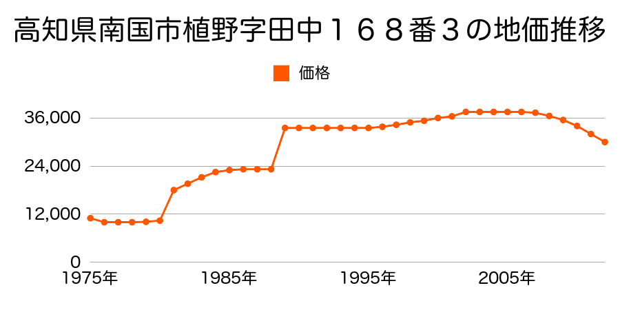
As the result of the real estate appraisal carried out on Jan 01, 2012, the land value for real estate of Hie, Nankoku, Kochi Prefecture 783-0054, Japan was determined for 30,000 yen / m².
Real estate appraisal report (partly written in Japanese)
| Researched at | 01 Jan, 2012 |
|---|---|
| Lot number(Chiban) | 高知県南国市比江字西野々348番4 |
| Address | Hie, Nankoku, Kochi Prefecture 783-0054, Japan |
| Price | 30,000yen/㎡ |
| Access | Gomen , 3 , 000 M |
| Acreage | 331㎡ |
| Aspect ratio | (1.0:1.0) |
| Structure | 建物などの敷地、W(木造)2F |
| Present | residence |
| Water, sewer and gas services | Water, sewer and gas |
| The vicinity | 一般住宅と農家住宅が混在する住宅地域 |
| Main road | north 4.0m city road |
| The other roads | |
| Allocation of use zoning | other areas |
| Building‐to‐land ratio, Floor area ratio | 70(%),200(%) |
| Development area | controlled urbanization area |
| Natural environment |
Environment (Written in Japanese)
| 地形・地質 | 砂礫台地砂礫・岩質の土質でできた起伏の少ない地形のことである。土地開発は容易であり、造成地の地質は比較的強固である。 「国土交通省 地震に対する地盤の安全性 地形分類の評点」:3点(5点満点中) 扇状地性低地谷の出口など、河川流域の扇状の平地のことである。土地開発は非常に容易であり、造成地の地盤は一般的利用に耐えるものである。 地形性質上洪水や土石流の危険がある地域であり、上流のダム決壊や歴史的豪雨等、数十年から数百年に一度レベルの災害が発生した際には被害地域となる恐れがある。 「国土交通省 地震に対する地盤の安全性 地形分類の評点」:3点(5点満点中) |
|---|---|
| 土地利用・植生 | 宅地,水田 |
| 災害リスク:水害 | 浸水域(昭和47年(1972)9月 昭和47年台風20号) 過去の周辺地域の水害の確認が必要。 |
| 黄砂エアロゾル | PM10及びPM2.5の飛散それぞれ認められるため、対応が必要。 |
| 緯度・軽度 | 東経 33度6036545 北緯 133度6509009 |
Map
Hie, Nankoku, Kochi Prefecture 783-0054, JapanNishiyama, Nankoku, Kochi Prefecture 783-0029, Japan