Real estate appraisal report of Oharaya, Toyama, Toyama Prefecture 930-1328, Japan

15,100 yen
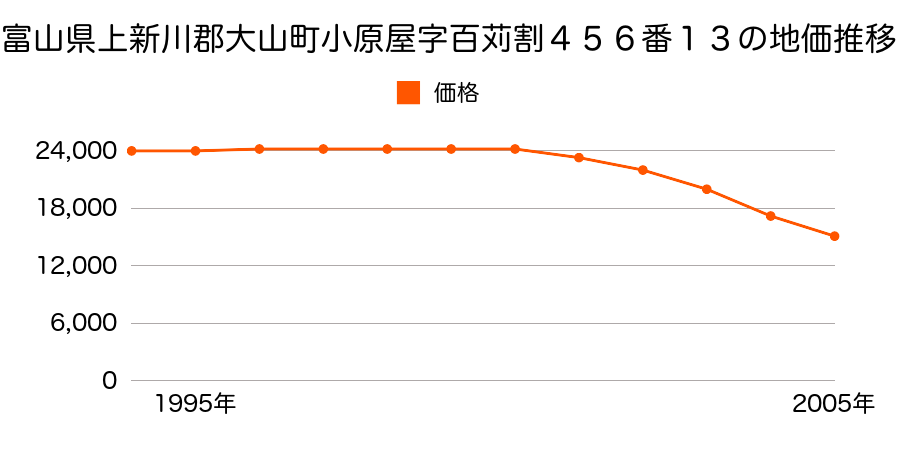
As the result of the real estate appraisal carried out on Jan 01, 2005, the land value for real estate of Oharaya, Toyama, Toyama Prefecture 930-1328, Japan was determined for 15,100 yen / m².
Real estate appraisal report (partly written in Japanese)
| Researched at | 01 Jan, 2005 |
|---|---|
| Lot number(Chiban) | 富山県上新川郡大山町小原屋字百苅割456番13 |
| Address | Oharaya, Toyama, Toyama Prefecture 930-1328, Japan |
| Price | 15,100yen/㎡ |
| Access | Daishou , 900 M |
| Acreage | 237㎡ |
| Aspect ratio | (1.0:1.5) |
| Structure | 建物などの敷地、W(木造)2F |
| Present | residence |
| Water, sewer and gas services | Water, sewer and gas |
| The vicinity | 中規模住宅が建ち並ぶ周辺に田地の多い住宅地域 |
| Main road | north west 4.0m town road |
| The other roads | |
| Allocation of use zoning | other areas |
| Building‐to‐land ratio, Floor area ratio | 60(%),200(%) |
| Development area | city‐planning area |
| Natural environment |
Environment (Written in Japanese)
| 地形・地質 | 扇状地性低地谷の出口など、河川流域の扇状の平地のことである。土地開発は非常に容易であり、造成地の地盤は一般的利用に耐えるものである。 地形性質上洪水や土石流の危険がある地域であり、上流のダム決壊や歴史的豪雨等、数十年から数百年に一度レベルの災害が発生した際には被害地域となる恐れがある。 「国土交通省 地震に対する地盤の安全性 地形分類の評点」:3点(5点満点中) |
|---|---|
| 土地利用・植生 | 水田 |
| 災害リスク:水害 | 大鳶崩壊に伴う氾濫域(安政5年(1858)3月10日 大鳶崩壊) 過去の周辺地域の水害の確認が必要。 |
| 黄砂エアロゾル | PM10の飛散は国内においては比較的少ない。PM2.5の飛散については特に少ないというわけでは無いため対策が必要。 |
| 緯度・軽度 | 東経 36度6160513 北緯 137度2829317 |
Map
Nakadaki, Toyama, Toyama Prefecture 930-1313, JapanMimuroaraya, Toyama, Toyama Prefecture 930-1314, Japan205-27 Zenna, Toyama-shi, Toyama-ken 930-1303, JapanNakadaki, Toyama, Toyama Prefecture 930-1313, JapanMimuroaraya, Toyama, Toyama Prefecture 930-1314, JapanMimuroaraya, Toyama, Toyama Prefecture 930-1314, Japan246 Tsuwami, Toyama-shi, Toyama-ken 930-1332, Japan