Real estate appraisal report of 4 Chome-6-13 Chūō, Takehara-shi, Hiroshima-ken 725-0026, Japan

69,000 yen
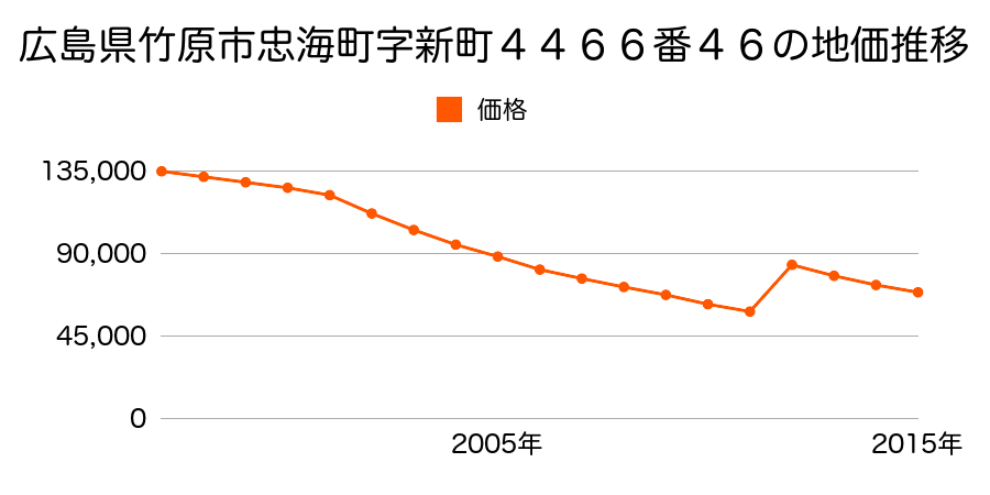
As the result of the real estate appraisal carried out on Jul 01, 2015, the land value for real estate of 4 Chome-6-13 Chūō, Takehara-shi, Hiroshima-ken 725-0026, Japan was determined for 69,000 yen / m².

Real estate appraisal report (partly written in Japanese)
| Researched at | 01 Jul, 2015 |
|---|---|
| Lot number(Chiban) | 広島県竹原市中央4丁目1381番4外 |
| Address | 中央4−6−13 4 Chome-6-13 Chūō, Takehara-shi, Hiroshima-ken 725-0026, Japan |
| Price | 69,000yen/㎡ |
| Access | Takehara , 440 M |
| Acreage | 208㎡ |
| Aspect ratio | (1.5:1.0) |
| Structure | 建物などの敷地、S(鉄骨造)4F |
| Present | office |
| Water, sewer and gas services | Water, sewer and gas |
| The vicinity | 中低層の事務所、店舗等が建ち並ぶ国道沿いの商業地域 |
| Main road | north west 20.0m national road |
| The other roads | 南西側道 |
| Allocation of use zoning | commercial districts, quasi-fire prevention districts |
| Building‐to‐land ratio, Floor area ratio | 80(%),400(%) |
| Development area | city‐planning area |
| Natural environment |
Environment (Written in Japanese)
| 地形・地質 | 人工地形埋立地のように人工的に造成された土地。地震に対する地盤の強度は十分ではなく、地震の際には液状化などのリスクが非常に高い。 海運・倉庫等、用途が明確で用地取得時のメリットと災害時のリスクを差し引きして価値を見出せるビジネス以外で用いるべきではない。 「国土交通省 地震に対する地盤の安全性 地形分類の評点」:3点(5点満点中) |
|---|---|
| 土地利用・植生 | 宅地,水田 |
| 黄砂エアロゾル | PM10及びPM2.5の飛散それぞれ認められるため、対応が必要。 |
| 緯度・軽度 | 東経 34度340975 北緯 132度9071494 |
Map
Shimonocho, Takehara, Hiroshima Prefecture 725-0012, Japan1 Chome-2-4 Chūō, Takehara-shi, Hiroshima-ken 725-0026, Japan2 Chome-8-2 Shiomachi, Takehara-shi, Hiroshima-ken 725-0025, Japan5 Chome-3-32 Chūō, Takehara-shi, Hiroshima-ken 725-0026, JapanJapan, 〒725-0012 Hiroshima-ken, Takehara-shi, Shimonochō, 3469 市立中通小学校Takehara, Hiroshima Prefecture, Japan
Related information
Takehara Station(41,300円 / m²)Daijou Station(51,100円 / m²)Market price in Hiroshimaken (Descending)
| Hijiyamabashi Station | 170,500 yen / m² |
| Hijiyamashita Station | 165,000 yen / m² |
| Hiroshima Station | 165,000 yen / m² |
| Tenjingawa Station | 160,500 yen / m² |
| Kouyou Station | 156,000 yen / m² |
| Yaga Station | 156,000 yen / m² |
| Kaitaichi Station | 132,000 yen / m² |
| Saijou Station | 112,000 yen / m² |
| Yano Station | 110,000 yen / m² |
| Shininokuchi Station | 107,000 yen / m² |
Market price in Hiroshimaken (Ascending)
| Shimokawabe Station | 23,750 yen / m² |
| Bingomikkaichi Station | 30,150 yen / m² |
| Nanatsuka Station | 31,500 yen / m² |
| Bingoshoubara Station | 32,650 yen / m² |
| Fuchuu Station | 33,000 yen / m² |
| Ukai Station | 39,000 yen / m² |
| Takagi Station | 40,500 yen / m² |
| Takehara Station | 41,300 yen / m² |
| Higashionomichi Station | 42,100 yen / m² |
| Kurepootopia Station | 45,650 yen / m² |
Change of market price in Hiroshimaken (Descending)
| Kouyou Station | +7.59% |
| Yaga Station | +7.59% |
| Koyaura Station | +6.76% |
| Tenjingawa Station | +5.25% |
| Kanbe Station | +5.22% |
| Hijiyamabashi Station | +4.92% |
| Kaitaichi Station | +4.76% |
| Miyauchikushido Station | +4.69% |
| Saijou Station | +3.23% |
| Hijiyamashita Station | +3.12% |
Change of market price in Hiroshimaken (Ascending)
| Yoshiura Station | -33.77% |
| Kawaraishi Station | -18.75% |
| Akiaga Station | -16.53% |
| Higashionomichi Station | -14.78% |
| Yokoo Station | -14.55% |
| Hiro Station | -13.94% |
| Shinhiro Station | -13.94% |
| Ajinahigashi Station | -9.36% |
| Hatsukaichi Station | -8.71% |
| Karugahama Station | -7.97% |
Market price in Japan (Descending)
| Yuurakuchou Station | 12,200,000 yen / m² |
| Toukyou Station | 12,000,000 yen / m² |
| Kyoubashi Station | 10,365,000 yen / m² |
| Nihonbashi Station | 6,990,000 yen / m² |
| Hacchoubori Station | 6,600,000 yen / m² |
| Sakuradamon Station | 3,155,000 yen / m² |
| Kouji Machi Station | 2,810,000 yen / m² |
| Hanzoumon Station | 2,745,000 yen / m² |
| Takebashi Station | 2,700,000 yen / m² |
| Kudanshita Station | 2,700,000 yen / m² |
Market price in Japan (Ascending)
| Akabira Station | 3,900 yen / m² |
| Kitayoshihara Station | 6,050 yen / m² |
| Hagino Station | 6,700 yen / m² |
| Shintotsukawa Station | 8,050 yen / m² |
| Takigawa Station | 8,100 yen / m² |
| Nakata Station | 8,850 yen / m² |
| Mokuzou Station | 8,850 yen / m² |
| Kawabe Station | 9,300 yen / m² |
| Fujisaki Station | 9,300 yen / m² |
| Motowanishi Station | 10,800 yen / m² |
Change of market price in Japan (Descending)
| Ooizumi Station | +142.74% |
| Hacchoubori Station | +124.87% |
| Jinbou Machi Station | +118.85% |
| Hobara Station | +116.55% |
| Kawasaki Station | +91.72% |
| Akihabara Station | +88.46% |
| Kudanshita Station | +87.5% |
| Takashima Machi Station | +86.73% |
| Bakuro Machi Station | +82.88% |
| Shinokachimachi Station | +71.61% |
Change of market price in Japan (Ascending)
| Higashihonganjimae Station | -73.47% |
| Nagoya Station | -65.43% |
| 西11丁目 Station | -65.01% |
| 西15丁目 Station | -61.59% |
| Chiyokenchouguchi Station | -60.43% |
| Susuki No Station | -59.77% |
| Okayama Station | -57.54% |
| Atagobashi Station | -54.91% |
| 西18丁目 Station | -53.33% |
| Kohashi Station | -52.11% |
